Pros And Cons Of Mercator Projection
Imagine standing on a vast, windswept beach, gazing out at the boundless expanse of the ocean. The waves crash against the shore, and you can almost taste the salty spray in the air.
Now, imagine that same scene captured on a map – a representation of our world that allows us to explore its wonders from the comfort of our homes.
Enter the Mercator Projection, a cartographic tool that has shaped our understanding of geography for centuries. While this projection offers an accurate depiction of shape and direction, it also comes with its fair share of drawbacks.
From distortion in size and distance to Eurocentric bias, there are pros and cons to consider when using this map projection. In this article, we will delve into these advantages and disadvantages, exploring their impact on navigation, perception, and our understanding of the world around us.
So grab your compass and join us as we navigate through the complexities of the Mercator Projection!
Pros of Mercator Projection
- Cylindrical Representation: The Mercator projection uses a cylindrical method. This conceptual approach, wrapping a cylinder around the Earth, makes it particularly suitable for certain applications, especially those involving navigation.
- Historical Significance: Presented by Gerardus Mercator in 1569, this projection has a longstanding history in cartography, highlighting its importance over the years.
- Standard for Navigation: The Mercator projection consistently represents north as up and south as down, preserving local directions and shapes, making it a primary choice for sailors and aviators.
- Straight Line Trajectories: The projection turns trajectories of constant bearing into straight lines, simplifying the process of plotting courses for marine navigation.
- Useful for Navigational Tools: Using the Mercator projection, navigators can easily measure courses and bearings with tools like compass roses or protractors. Directions can also be straightforwardly transferred from point to point on the map.
- Widely Accepted for Navigational Charts: Its widespread use in navigation charts signifies the trust and reliability placed in this projection system by global navigators.
- Constant True Bearing: A standout feature is that any straight line on a Mercator map represents a line of constant true bearing, which is a boon for navigators.
- Preserves Local Shapes: One of the reasons for its popularity is its ability to preserve local shapes, which can be crucial for detailed regional maps.
- Universal Direction Representation: North is always up, and south is always down. This consistency can be comforting and less confusing for users accustomed to this orientation.
- Ease of Use with Modern Tools: The straight lines and consistent bearings mean that modern tools and software can easily interface with maps based on the Mercator projection.
Cons of Mercator Projection
- Distorted Scale: The Mercator projection has a scale that gets distorted, making it problematic for world maps as areas farther from the Equator appear disproportionately large.
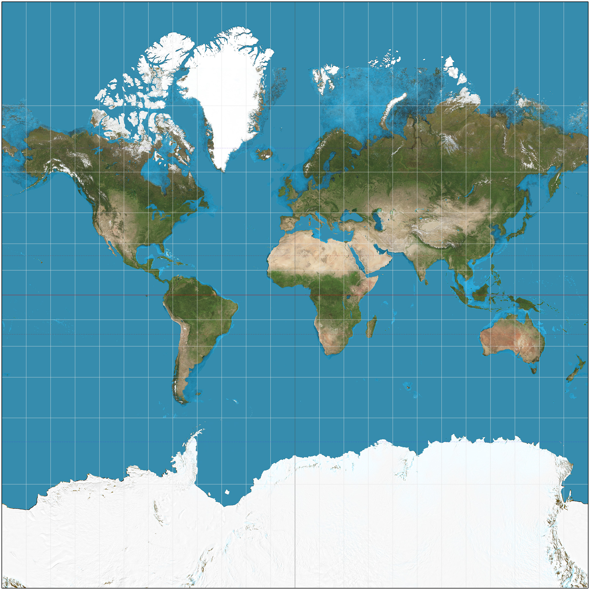
- Misrepresentation of Area: Landmass representations can be majorly flawed. For instance, Greenland appears larger than South America on the map, though this is far from reality.
- Exaggerated Polar Regions: Regions near the poles, like Greenland, Antarctica, Canada, and Russia, appear much larger than they actually are.
- Not Suitable for World Maps: The pronounced distortions at high latitudes make it less practical for general world maps.
- Potential for Misleading Interpretations: The inherent scale inflation might lead to misleading interpretations about political importance based on the distorted sizes of regions.
- Area Inaccuracies: Its design leads to significant inaccuracies in the representation of areas, especially as one moves towards the poles.
- Doesn’t Represent the Entire Globe: Due to the distortions, the Mercator can’t accurately depict the entire Earth, especially near the poles.
- Misunderstanding of Actual Distances: Distances can be misrepresented, especially over long stretches, potentially leading to miscalculations in real-world applications.
- Lacks Equatorial Emphasis: Regions near the Equator, which are significant in terms of biodiversity and population, can appear smaller and hence might be deemphasized.
- Promotes Northern Hemisphere Bias: Because northern regions appear larger, it can inadvertently promote a bias towards the northern hemisphere, skewing perceptions of size and importance.
Accurate Representation of Shape and Direction
You’ll love how the Mercator projection makes everything look so accurate and true to form, but little do you know that it’s as outdated as using a floppy disk in this digital age.
One of the pros of the Mercator projection is its ability to provide an accurate representation of shape and direction. When you look at a Mercator map, you can easily identify the shapes of continents and countries while also being able to determine their relative positions. This is especially useful for navigational purposes.
However, one major con of this projection is the distortion of size and distance. As you move further away from the equator, objects appear larger than they actually are, giving a misleading perception of landmasses and distances between them. So while it may seem accurate at first glance, closer inspection reveals its flaws.
Distortion of Size and Distance
Experience a distorted representation of land sizes and distances when viewing maps using the Mercator projection. The advantages of this projection are that it preserves angles and shapes, making it useful for navigation purposes. However, it greatly distorts the size and distance of objects near the poles.
As you move closer to the poles, areas appear significantly larger than they actually are. This can lead to misconceptions about the true size of countries or continents, with Greenland appearing larger than South America, for example.
Additionally, distances between places near the poles are exaggerated on Mercator maps. This can result in inaccuracies when planning travel routes or estimating travel times.
So while the Mercator projection has its benefits, its distortion of size and distance is an important factor to consider when interpreting these types of maps.
Navigational Usefulness
To truly navigate with accuracy, it’s important to understand the navigational usefulness of maps. The Mercator projection, despite its size and distance distortions, has had historical significance in navigation. Here are three ways it has impacted trade routes:
- It provided a standardized map for sailors to plan their voyages. With its straight lines of latitude and longitude, it allowed navigators to plot their courses more easily.
- The Mercator projection helped identify the shortest routes between different ports around the world. This was especially crucial during the Age of Exploration when European nations were establishing global trade networks.
- By accurately representing direction, the Mercator projection aided in determining compass headings and navigating through open waters.
Understanding these aspects of the Mercator projection gives us insight into its role in shaping historical trade routes and facilitating accurate navigation on long voyages at sea.
Eurocentric Bias
One must recognize the Eurocentric bias in maps to fully grasp their impact on historical trade routes. The Mercator projection, while useful for navigation, has had significant implications on global trade and cultural understanding.
By distorting the size of landmasses, it magnifies the importance of Europe and diminishes the significance of other regions. This misrepresentation has perpetuated a Eurocentric worldview, reinforcing the idea that Europe is at the center of global affairs. Consequently, this has influenced trade patterns and economic relationships, with European powers historically dominating international commerce.
Moreover, this bias has also contributed to cultural misunderstandings and stereotypes by marginalizing non-European cultures and their contributions to history. It is crucial to acknowledge and address this Eurocentric bias in maps to foster a more accurate representation of our interconnected world.
Impact on Perception and Understanding of the World
The distorted representation of landmasses in maps has significantly shaped and influenced our perception and understanding of the world. The Mercator projection, with its Eurocentric bias, has had profound cognitive effects and cultural implications.
- Exaggerated sizes: The Mercator projection magnifies the size of landmasses near the poles, giving a distorted perception of their actual size. This can lead to an overestimation of the importance and dominance of certain countries or regions.
- Marginalization: By emphasizing Europe in the center of the map, the Mercator projection perpetuates a Eurocentric view that marginalizes other parts of the world. This can reinforce existing power imbalances and contribute to a sense of superiority among European cultures.
- Misunderstanding geography: Due to its distortions, the Mercator projection can misrepresent distances between places. This can result in a skewed understanding of global spatial relationships and hinder cross-cultural communication and cooperation.
The use of the Mercator projection has had far-reaching consequences on how we perceive and understand our world, impacting both our cognitive processes and cultural dynamics.
Alternative Map Projections
Now that you understand how the Mercator projection affects our perception and understanding of the world, let’s explore some alternative map projections.
It’s important to know that there are various types of map projections available, each with its own advantages and disadvantages. These alternative map projection types aim to address the drawbacks of the Mercator projection.
One such example is the Robinson projection, which attempts to balance distortion in size, shape, distance, and direction.
Another popular option is the Winkel Tripel projection, which provides a more realistic depiction of landmasses while still maintaining relatively accurate sizes.
Additionally, the Eckert IV projection seeks to minimize distortion by dividing Earth into equal-area regions.
By considering these different map projections, we can gain a more comprehensive understanding of our planet’s true geography while mitigating some of the limitations imposed by the Mercator projection.
Conclusion: Is the Mercator Projection Still Relevant?
Imagine a world where our perception of landmasses, distances, and directions isn’t constrained by a single map projection but instead embraces the diversity and accuracy offered by alternative methods.
In this world, the relevance of the Mercator projection would be questioned. While the Mercator projection has been widely used for centuries, its limitations have become increasingly apparent. Its distortion of landmasses near the poles and exaggeration of size make it less accurate for representing global geography. This can impact geographic education as it perpetuates misconceptions about relative sizes and distances between countries.
Embracing alternative map projections that prioritize accuracy can lead to a more comprehensive understanding of our planet’s geography. By incorporating different perspectives into geographic education, we can better navigate our interconnected world.
Frequently Asked Questions
How does the Mercator Projection affect the perception of the size of countries and continents?
The Mercator projection distorts the perception of country and continent sizes, creating a perception bias. It exaggerates the size of landmasses near the poles, making them appear much larger than they actually are.
Are there any other map projections that are more accurate in representing both shape and size?
When comparing map projections and evaluating map accuracy, there are several other options that are more accurate in representing both shape and size compared to the Mercator projection.
How does the Eurocentric bias of the Mercator Projection impact the perception of global power and influence?
The Eurocentric bias of the Mercator projection distorts the perception of global power dynamics by exaggerating the size and importance of Western countries, reinforcing colonial influences on global perceptions of power and influence.
What are the potential drawbacks or limitations of using the Mercator Projection for navigation purposes?
Navigating with the Mercator projection? Well, get ready for some serious stretching! This map may make Greenland look gigantic, but that’s just one of its many limitations and drawbacks. Good luck finding your way!
How does the Mercator Projection influence people’s understanding of the true extent of certain regions, such as Greenland?
The Mercator projection distorts the size of Greenland and other regions. This can lead to a misperception of their true extent, which has cultural implications. To overcome this distortion, alternative map projections can be used.
